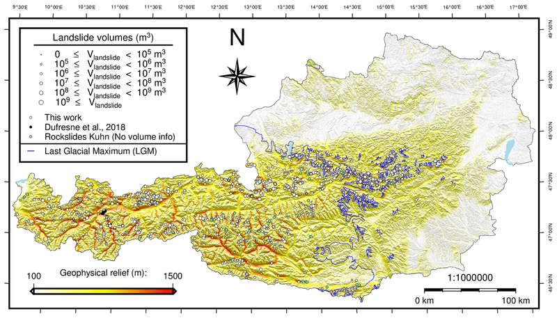
Recent Study (NHESS 2021)Controls on the formation and size of potential landslide dams and dammed lakes in the Austrian AlpsArgentin A-L., Robl J., Prasicek G., Hergarten S., Hölbling D., Abad L. and Z. Dabiri Stay tuned! Controls on landsliding have long been studied, but the potential for landslide-induced dam and lake formation has received less attention. Here, we model possible landslides and the formation of landslide dams and lakes in the Austrian Alps. We combine a slope criterion with a probabilistic approach to determine landslide release areas and volumes. We then simulate the progression and deposition of the landslides with a fluid dynamic model. We characterize the resulting landslide deposits with commonly used metrics, investigate their relation to glacial land-forming and tectonic units, and discuss the roles of the drainage system and valley shape. We discover that modeled landslide dams and lakes cover a wide volume range. In line with real-world inventories, we further found that lake volume increases linearly with landslide volume in the case of efficient damming – when an exceptionally large lake is dammed by a relatively small landslide deposit. The distribution and size of potential landslide dams and lakes depends strongly on local topographic relief. For a given landslide volume, lake size depends on drainage area and valley geometry. The largest lakes form in glacial troughs, while the most efficient damming occurs where landslides block a gorge downstream of a wide valley, a situation preferentially encountered at the transition between two different tectonic units. Our results also contain inefficient damming events, a damming type that exhibits different scaling of landslide and lake metrics than efficient damming and is hardly reported in inventories. We assume that such events also occur in the real world and emphasize that their documentation is needed to better understand the effects of landsliding on the drainage system.
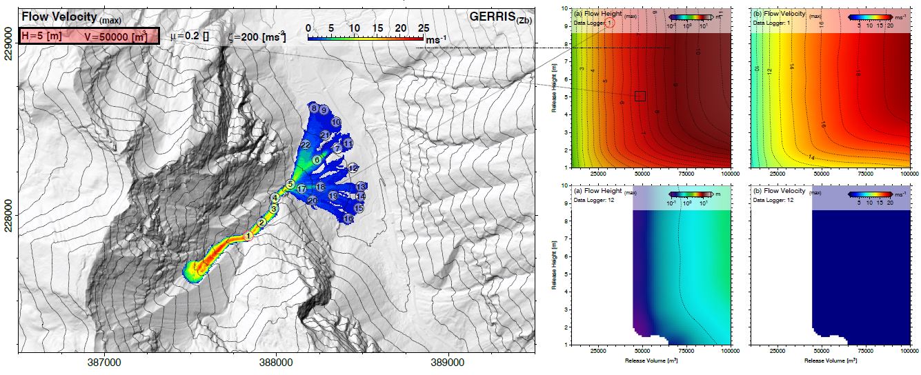
Recent Study (in prep.)Impact and sensitivity of parameters in debris flow modelsRobl J. and S. Hergarten Stay tuned! Debris flows are globally abundant threats for settlements and infrastructure in mountainous regions. Crucial influencing factors for hazard zone planning and mitigation strategies are based on numerical models that describe granular flow on general topography by solving a depth-averaged form of the Navier Stokes equations in combination with an appropriate flow resistance law. In case of debris flows, the Voellmy rheology is a widely used constitutive law describing the flow resistance. Parameters of the Vollemy fluid are determined by back analysis from observed events so that modelled events mimic their historical counterparts.
Determined parameters characterizing individual debris flows show a large variability (related to fluid composition and surface roughness). However, there may be several sets of parameters that lead to a similar depositional pattern but cause large differences in flow velocity and momentum along the flow path. Fluid volumes of hazardous debris flows are estimated by analyzing historic events, precipitation time series, hydrographs or empirical relationships that correlate fluid volumes and drainage areas of torrential catchments. Beside uncertainties in the determination of the fluid volume the position and geometry of the initial masses of forthcoming debris flows are in general not well constrained but heavily influence the flow dynamics and the depositional pattern even in the run-out zones. In this study, we systematically explore effects of the aforementioned parameters on run-out distance, inundated area and momentum. Our results indicate that the spatial position and geometry of the release volume in combination with various parameter sets within a realistic range of parameters characterizing the Voellmy fluid heavily influence momentum, inundated areas and run-out distances. Even worse, different parameter sets lead to very similar depositional pattern but may differ in momentum along the flow path by more than one order of magnitude and beyond. Modeling rapid mass movements using the shallow water equationsWe propose a new method to
model rapid mass movements on complex topography using the shallow water
equations in Cartesian coordinates. These equations are the widely used standard
approximation for the flow of water in rivers and shallow lakes, but the main
prerequisite for their application – an almost horizontal fluid table – is in
general not satisfied for avalanches and debris flows in steep terrain.
Therefore, we have developed appropriate correction terms for large topographic
gradients. In this study we present the mathematical formulation of these
correction terms and their implementation in the open-source flow solver GERRIS.
This novel approach is evaluated by simulating avalanches on synthetic and
finally natural topographies and the widely used Voellmy flow resistance law.
Testing the results against analytical solutions and the proprietary avalanche
model RAMMS, we found a very good agreement. As the GERRIS flow solver is freely
available and open source, it can be easily extended by additional fluid models
or source areas, making this model suitable for simulating several types of
rapid mass movements. It therefore provides a valuable tool for assisting
regional-scale natural hazard studies. 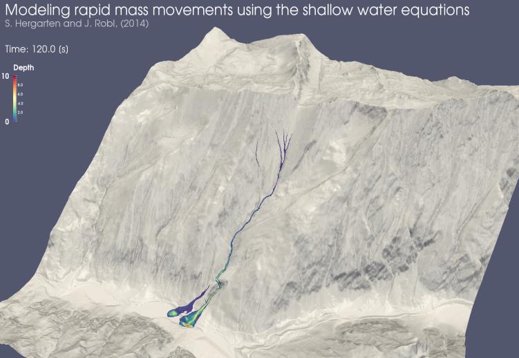 |