Recent Study (in revision)

The linear feedback precipitation model (LFPM) - a simple and efficient model for orographic precipitation in the context of landform evolution modeling


Hergarten S. and J. Robl

Read the entire study!

MOVIES: Impact of model parameters on the Precipitation Pattern | India-Asia

MOVIES: Co-Evolution of Precipiation and Topographie

See also Stefan Hergartens openlem page: http://hergarten.at/openlem/


Read the entire study!

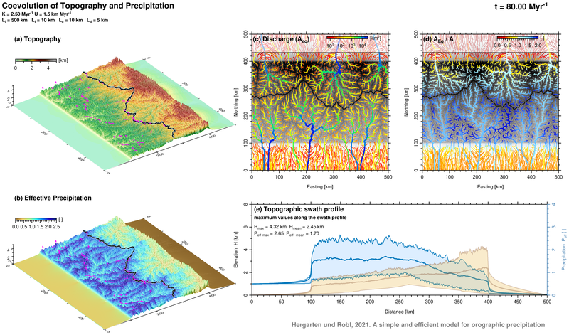
The influence of climate on landform evolution has received great interest over the past decades. While many studies aim at determining erosion rates or parameters of erosion models, feedbacks between tectonics, climate and landform evolution have been discussed, but addressed quantitatively only in a few modeling studies. One of the problems in this field is that coupling a large-scale landform evolution model with a regional climate model would dramatically increase the theoretical and numerical complexity. Only a few simple models are available so far that allow a numerical efficient coupling between topography-controlled precipitation and erosion. This paper fills this gap by introducing a quite simple approach involving two vertically integrated moisture components (vapor and cloud water).  Even simple numerical experiments applying such a coupled landform evolution model show the strong impact of spatial precipitation gradients on mountain range geometry including steepness and peak elevation, position of the principal drainage divide, and drainage network properties. 


Recent Study

lineaDEM – a R package for morphometric and automated lineament analysis on digital elevation models

 Baumann S., Robl J., Wendt L., Willingshofer E. and S. Hilberg

The package offers basic morphometric analyses on digital elevation models such as hypsometry, elevation-slope relations and moving window filters to generate local minima or maxima and generates a directed path following these extrema (e.g. longitudinal river profiles).Main focus of the package is automated lineament detection. A multi-directional, multi-scale roughness filter and an iterative Hough-transformation detect lineaments that solely rely on elevation information and therefore show no illumination effect. For technical guidance and examples of the functions please see the lineaDEM-manual. Download R-package, Manual

Tectonic geomorphology at small catchment sizes – extensions of the stream-power approach and the χ method (2016)

Hergarten S., Robl J. and K. Stüwe

Read the entire study!

 In this study we present and discuss some empirically derived extensions of the stream power law towards small catchment sizes in order to overcome limitations for small catchment sizes. Beyond this, we introduce a simple method for estimating the adjustable parameters in the original χ method as well as in our extended approaches. As a main result, an approach originally suggested for debris flow channels seems to be the best approximation if both large and small catchment sizes are included in the same analysis.


Extracting topographic swath profiles across curved geomorphic features (2014)

Hergarten S., Robl J. and K. Stüwe

Read the entire study!

We present a new method to extend the widely used geomorphic technique of swath profiles towards curved geomorphic structures such as river valleys. In contrast to the established method that hinges on stacking parallel cross sections, our approach does not refer to any individual profile lines, but uses the signed distance from a given baseline (for example, a valley floor) as the profile coordinate. The method can be implemented easily for arbitrary polygonal baselines and for rastered digital elevation models as well as for irregular point clouds such as laser scanner data. Furthermore it does not require any smoothness of the baseline and avoids over- and undersampling due to the curvature of the baseline. The versatility of the new method is illustrated by its application to topographic profiles across valleys, a large subduction zone, and the rim of an impact crater. Similarly to the ordinary swath profile method, the new method is not restricted to analyzing surface elevations themselves, but can aid the quantitative description of topography by analyzing other geomorphic features such as slope or local relief. It is even not constrained to geomorphic data, but can be applied to any two-dimensional data set such as temperature, precipitation or ages of rocks.

Meteor Crater