Recent Study (EPSL 2020)
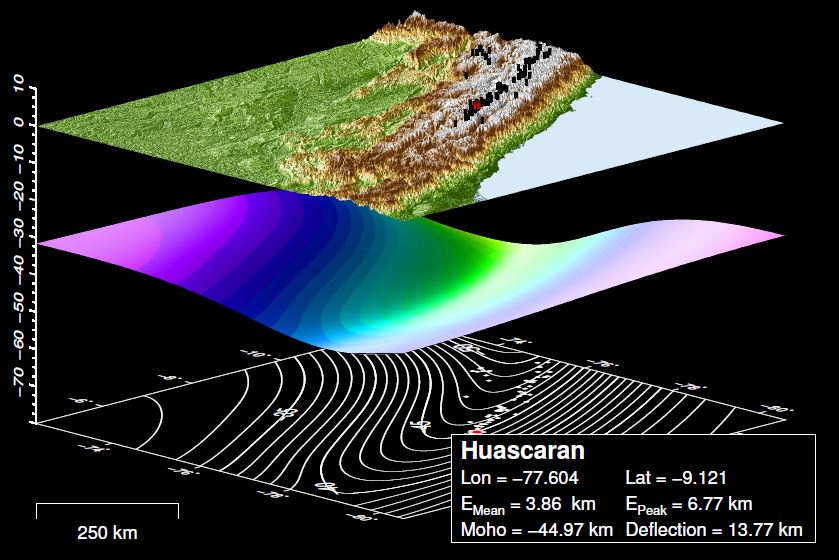
Glacial erosion promotes high mountains on thin crust
Robl J., Hergarten S. and G. Prasicek
Read the entire study!
Here we present the first
global analysis of the morphology and distribution of more than 16,000 peaks. We
spatially correlate peak height and steepness with mean elevation and crustal
thickness. Our analysis reveals that the steepness of peaks increases with
altitude. Comparing peaks of similar altitude, the steepness of peaks increases
towards high latitudes, while the crustal thickness supporting these peaks
decreases. This evidences for a progressive crustal thinning with intensity and
duration of glacial occupation transforming mountain belts from a fluvial
towards a glacial topography. Due to the characteristic glacial landscape
geometry with very steep peaks separated by spacious glacial valleys even a
relatively thin crust is sufficient to supporting very high peaks.
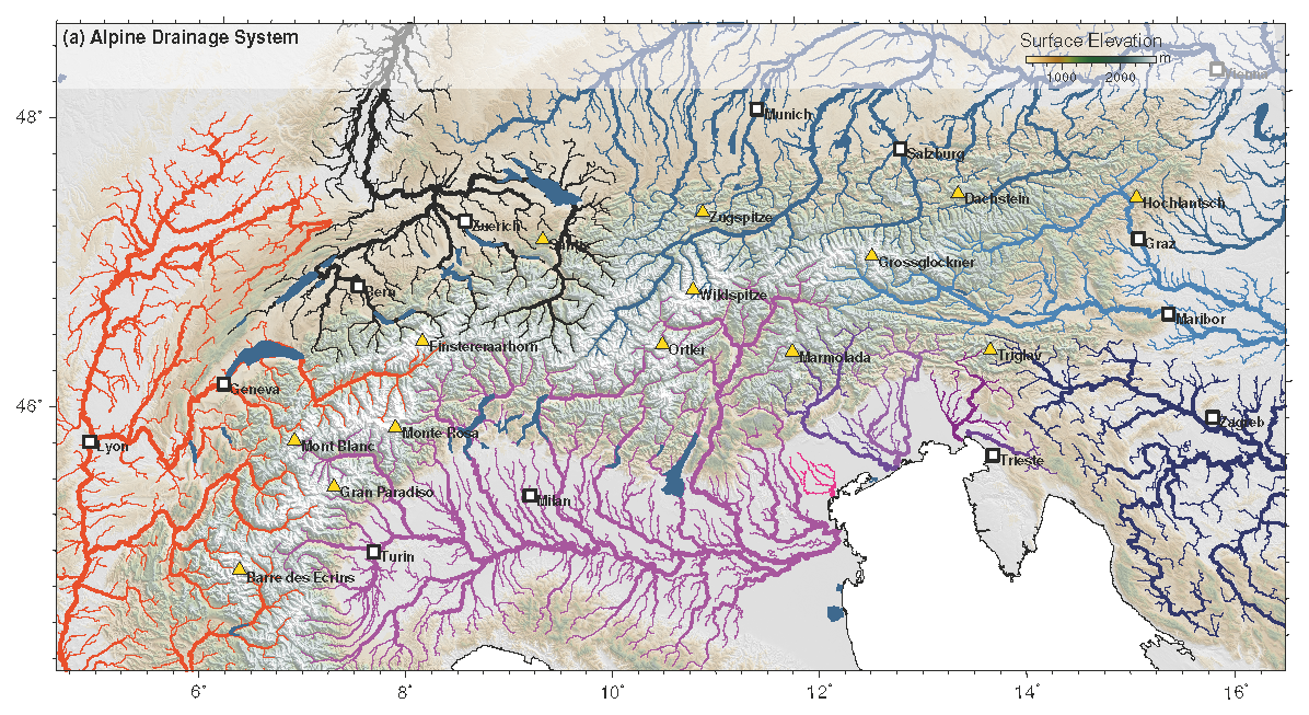
The destiny of orogen-parallel streams in theEastern Alps: the
Salzach–Enns drainage system
Trost G., Robl J., Hergarten S., Neubauer S.
Read the entire study!
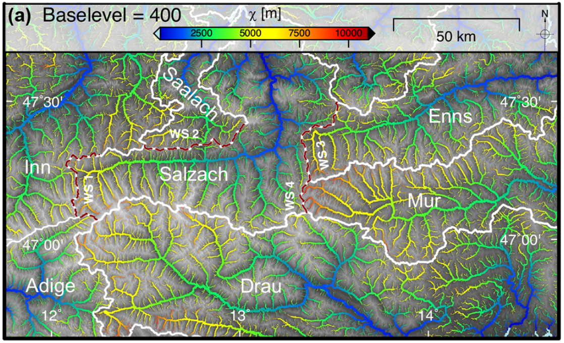
The evolution of the drainage system in the Eastern Alps is inherently linked to
different tectonicstages of the alpine orogeny. Crustal-scale faults imposed
eastward-directed orogen-parallel flow on major rivers,whereas late orogenic
surface uplift increased topographic gradients between the foreland and range
and hencethe vulnerability of such rivers to be captured. This leads to a
situation in which major orogen-parallel alpinerivers such as the Salzach River
and the Enns River are characterized by elongated east–west-oriented
catchmentssouth of the proposed capture points, whereby almost the entire
drainage area is located west of the capture point.To determine the current
stability of drainage divides and to predict the potential direction of divide
migration,we analysed their geometry at catchment, headwater and hillslope scale
covering timescales from millions ofyears to the millennial scale. We
employχmapping for different base levels, generalized swath profiles
acrossdrainage divides and Gilbert metrics – a set of local topographic metrics
quantifying the asymmetry of drainagedivides at hillslope scale. Our results
show that most drainage divides are asymmetric, with steeper channels westand
flatter channels east of a common drainage divide. Interpreting these results,
we propose that drainage dividesmigrate from west towards east so that the Inn
catchment grows at the expense of the Salzach catchment andthe Salzach catchment
consumes the westernmost tributaries of the Mur and Enns catchments. Gilbert
metricsacross the Salzach–Enns and Salzach–Mur divides are consistent with
inferred divide mobility. We attributethe absence of divide asymmetry at the
Inn–Salzach divide to glacial landforms such as cirques and U-shapedvalleys,
which suggest that Pleistocene climate modulations are able to locally obscure
the large-scale signal ofdrainage network reorganization. We suggest that the
eastward-directed divide migration progressively leads tosymmetric catchment
geometries, whereby tributaries west and east of the capture point eventually
contributeequally to the drainage area. To test this assumption, we have
reconstructed the proposed drainage networkgeometries for different time
slices.χmapping of these reconstructed drainage networks indicates a
progressivestability of the network topology in the Eastern Alps towards the
present-day situation.
|
The effects of lithology and base level on topography in the northern Alpine Foreland
Baumann S., Robl J., Prasicek G., Salcher B. and M. Keil
Read the entire study!
The evolution of topography is driven by climate and tectonics, and strongly
influenced by substrate properties and different base levels. The contributions
of these factors may vary in space and time and are thus difficult to
disentangle. Our study area, the Hausruck - Kobernaußerwald range, has a rather
uniform climatic and tectonic history but is drained by rivers with different
base levels and consists of contrasting sedimentary rocks, mainly due to
different sedimentation environments. This makes them an ideal location to study
the effects of lithology and base level on topography.
|
Topographic evolution of the Eastern Alps: The influence of
strike-slip faulting activity
Bartosch T., Stüwe K., and J. Robl
Read the entire study!
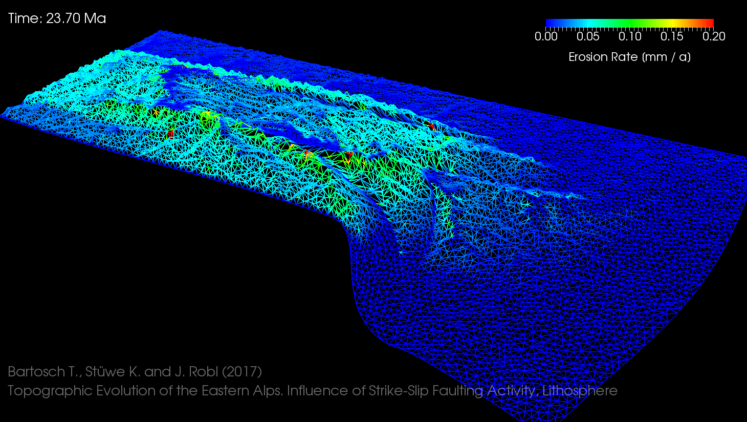
We present the results of a numerical model that was used to investigate aspects
of the landscape evolution of the Eastern European Alps in the Miocene. The
model allows the consideration of strike-slip faulting, an inherent feature of
the Miocene tectonics in the Eastern Alps, within a viscous medium. Mechanical
deformation of this medium is coupled with a landscape evolution model to
describe surface processes. For the input variables, the activity history of
strike-slip faulting in the Eastern Alps was compiled from literature sources.
The results present a major improvement in the predicted topographic development
over earlier models in terms of the location and build-up of valleys and
mountain ranges that form in response to the strike-slip faulting activity.
|
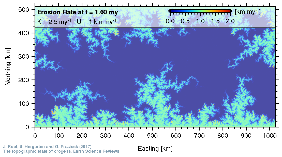
The Topographic State of Mountain Belts
Robl J., Hergarten S., and G. Prasicek
Read the entire study
The topography of mountain ranges reflects the
competition of constructive and destructive processes driven by tectonics and
climate, respectively. There is a vital debate whether the topography of
individual orogens reflects stages of growth, steady-state or decay that is
fueled by the million-year time scales hampering direct observations on
landscape evolution, the superposition of various process patterns and the
complex interactions among different processes. Hence, there is a demand for
sophisticated analysis tools to extract constraints on the long-term evolution
of orogens from their topography. We review the field of orogen-scale landscape
evolution from a numerical perspective, summarize the most prominent modelling
concepts and their implications for the fluvially-driven development of mountain
topography, and finally evaluate their applicability for understanding
real-world orogens.
|
The topography of a continental indenter: The interplay between
crustal deformation, erosion and base level changes in the eastern Southern Alps
Robl J., Heberer B., Prasicek G., Neubauer F. and S. Hergarten
Read the entire study!
The topography of the eastern Southern Alps (ESA)
reflects indenter tectonics causing crustal shortening, surface uplift and
erosional response. Fluvial drainages were perturbed by Pleistocene glaciations
that locally excavated alpine valleys. The Late Miocene desiccation of the
Mediterranean Sea and the uplift of the northern Molasse Basin led to
significant base level changes in the far field of the ESA and the Eastern Alps
(EA), respectively. Among this multitude of mechanisms, the processes that
dominate the current topographic evolution of the ESA and the ESA-EA drainage
divide have not been identified. We demonstrate the expected topographic effects
of each mechanism in a 1-dimensional model and compare them with observed
channel metrics. We find that the normalized steepness index increases with
uplift rate and declines from the indenter tip in the northwest to the foreland
basin in the southeast. The number and amplitude of knickpoints and the
distortion in longitudinal channel profiles similarly decrease towards the east.
Changes in slope of χ-transformed channel profiles coincide spatially
with the Valsugana - Fella fault linking crustal stacking and uplift induced by
indenter tectonics with topographic evolution. Gradients in χ across
the ESA-EA drainage divide imply an ongoing, north-directed shift of the
Danube-ESA watershed that is most likely driven by a base level rise in the
northern Molasse basin. We conclude that the regional uplift pattern controls
the geometry of ESA-EA channels, while base level changes in the far field
control the overall architecture of the orogen by drainage divide migration.
|
Alpine topography in the light of tectonic uplift and glaciation
Robl J., Prasicek G., Hergarten S. and S. Stüwe
Read the entire study!
In steady-state orogens, topographic gradients are
expected to increase with elevation whereas the European Alps feature a
transition from increasing to decreasing slopes. This peculiar pattern has been
interpreted to reflect either the critical slope stability angle or a premature
fluvial landscape but is also consistent with the glacial buzz-saw hypothesis.
To disentangle the contributions of each of these principles we split the Alps
into contiguous domains of structural units and analyze their slope–elevation
distributions emphasizing glaciated and non-glaciated realms. In comparable
structural units within the extent of the last glacial maximum (LGM) the
transition from increasing to decreasing slopes is located at the equilibrium
line altitude (ELA) of the LGM and we interpret this to be evidence for the
impact of glacial erosion. Decay rates of glacial landforms towards steady-state
slopes depend on lithological properties leading to a landscape characterized by
different transient states. Beyond the LGM limits the slope–elevation
distributions show local maxima as well, but these are located at varying
altitudes implying a tectonic driver. This observation and data from surrounding
basins suggests that at least parts of the European Alps experienced a
pre-Pleistocene pulse of tectonic uplift. The resulting presence of premature
low-gradient terrain above the ELA during the global cooling in Plio–Pleistocene
times would have heavily influenced the onset and the extent of an alpine ice
cap.
|
|
|
|
|
|
|
|
|